|
Skip to the tech spec page
I can't tell you how many times out on the trail we've seen, as the
crow flies, a location we wanted to reach but couldn't figure out
how to get around the mountain, across the canyon, or through the
trees. Many times, it's not the lack of trails that throws us
for a loop, but which one to take. We've usually got three
different maps with us, and sometimes even a satellite image of the
area we are headed out to, and switching between them all,
especially while being jostled around isn't the easiest task for the
navigator, which is usually me. So that, paired with the fact
that everyone else around me gets their own toys, got me to break
down and buy a nice GPS system. We already had a Garmin Etrex
in our gear, but there's only so much you can do with a tiny dot
matrix like display.
There
are plenty of GPS's out there that met most of my requirements, but
most of those weren't designed for portability. I really
wanted a good sized color screen that would display maps well.
Instead of just utilizing number coordinates, I wanted to see which
canyon I was in and what was around the next corner?
We
enjoy exploring caves and old mines when we are out, whether that
means just walking in a few feet, or rappelling down into them off
someone's bumper. Before we go out, I'll print out a nice
topographic map for us. Usually you can only get detailed ones
in small quadrants off the net, so I'd find the area, download like
20 squares, and then put them together in Corel. Then, I'd go
as far as laminating the completed map for durability, rain, and so
we could fold it up. The maps I get from
Maptech.com seem to be the most detailed and even have all the
mines listed already on them, so if we are in the area and there's
one nearby we can drop in.
I went
about looking on Ebay for a good GPS and narrowed it down to a
Garmin iQue 3600 and a Mitac Mio 168. I went through many
reviews on the products and they both seemed great units.
While these units matched either almost point for point, I went with
the Garmin for the name and the slightly larger screen. I
later found out how well Garmin backs their products and am
extremely pleased with my choice.
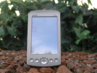
The iQue retails for over $500, but I found a "newly overhauled"
unit on Ebay for $300. It came like a brand new unit with a
full-year factory warranty from Garmin. It included:
|
 |
-
USB HotSync� cradle
-
A/C power/charging adapter
-
Quick start guide
-
Installation/Application CD with manual and
basemaps
-
Automotive friction mount with integrated
charger and speaker
-
Basemaps included on CD: Americas AutoRoute
-
MapSource City Select Version 7 with FULL
Unlock DVD's
-
Store receipt for
full one year Garmin Warranty
|
The warranty came in handy, since when the unit arrived, it wouldn't
hold a charge and would keep crashing, requiring a hard restart to
come back online. I called Garmin, they made me feel warm and
cozy about it and then told me where to send it in to. Three
business days after they received it, I had it back! Not only
that, but they sent me a brand spanking new one at no cost! I
was blown away with their customer service and am very thankful for
their dedication to their products.
|
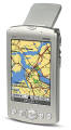
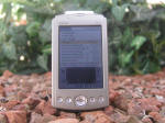
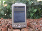
The 3600 runs on a
Palm OS platform and has a 200MHz processor. It only has
32MB of internal memory, but with an expansion flash card you
can download tons of maps or songs, since it plays MP3's too.
I went ahead and got a 1G card so I wouldn't fill it too fast.
I really liked the large color screen on this unit, a
backlit, high res 320 x 480 pixel color transflective display
with 16 bit, 65,000 colors. It makes map reading a lot
easier and more visable. |
|
This thing is
packed with features. To access the GPS, all you have to
do is to flip up the antenna on the back and your all set to
go. It tracks up to 12 satellites and is accurate to an
average of 15 feet, 3 feet when using WAAS (which eats up your
battery like crazy). It also updates once a second so it
works really well while tracking your movements.
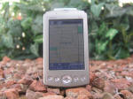
I really got it so I could download
and use the topographic maps on it, but I've found that the
included maps are extremely helpful. I never thought I'd
use it for it, but the driving maps are pretty cool. The
iQue comes with its own internal speaker and there is one on
the car cigarette adapter. You'd think a woman's voice
telling you where to go would be very annoying, but I can see
where'd it come in handy. I've used it in a few blind
tests to get to certain locations and it has been right on the
money. It zooms down to 120 feet which helps to identify
all the places you're passing that pop up on the screen.
Lots of places show up and information like phone numbers pop
up in the info box if you'd like. One function I've used
is finding where the nearest fast food place is to my
location, or where the next Safeway is on the way to fishing
(Fry's doesn't sell chicken livers- oh and it also tells you
when the best time to fish is at depending on what lake/river
you're at). If you know an address, you can also type it
in and get instant driving instructions to your destination.
And the route recalculation feature comes in handy too.
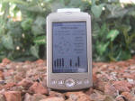
The Garmin comes with all the
regular Palm apps too- address book, date book, calc, memo
programs, alarm clock, etc. I've also downloaded a
couple games for it. Nothing like multitasking listening
to MP3's and playing 15 types on solitaire all while sitting
on the throne. Installing things on your Palm or the
card is easy, kind of like a drag and drop setup if you prefer
that approach. For the maps, you first pre-select the
area first on your computer and then shoot them over to your
handheld. As a bonus, the maps and location finder are
also on your computer so you can use them there as well. |
 |
 |
 |
 |
|